CBA Pahala

|
CBA Pahala | |
| Pahala Weather images and information from NOAA offices and satellites | Ka'u monthly newspaper | Forecast (Opens new browser window) |
Current GOES Infra-red Image | |||||||

| |||||||
US Visible Image loop | |||||||

| |||||||
|
Click on the picture of Mauna Kea for an animated view of the latest night sky from Mauna Kea. This will give an idea of the general level of high cloudiness present over the island. Mauna Kea is about 40 miles north of Pahala. | |||||||

| |||||||
| Jonathan Kemp of CBA Hilo has a
more complete weather page related to the area. | |||||||
US NOAA Weather Chart
| 
| Links to other pagesWeather Forecast for Pahala.Weather Office Products.Satellite Weather InterpretationWeather Radar Animated Loop.KITV Current HI Big Island zoomable radarLong term Patterns for AstronomyThe late Bill Albrecht, a prolific AAVSO observer, lived in Pahala for 20 years and made90,000 observations of variable stars. His data was analyzed to form an impression of the weather here. The plot on the right shows the percentage of nights per month when he observed. From this one can infer the frequency of clear, or partly clear nights throughout the year. 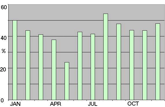
Average monthly rainfall for Pahala throughout the year | (Redrawn from Climate and Water Balance on the Island of Hawaii by James O. Juvik, D. C. Singleton, and G. G. Clarke, Department of Geography, University of Hawaii) 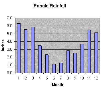
The Kiluea Eruption Update will give details on the latest activity of the | volcano. Pahala faces little threat from a lava flow from Kilauea, but does suffer the risk of high SO2 levels and ash deposits. Additionally, an explosive eruption from Kiluaea poses a remote possibility of smothering Pahala. Mauna Loa, which last erupted in 1984, lies directly above us. It has been inflating since May 2002. An eruption in the next decades is possible. Lew's CBA sites: | CBA Pahala CBA Concord Lew's Affiliation with the Center for Backyard Astrophysics |